Tuesday, December 14, 2010
Wednesday, December 1, 2010
Tuesday, November 30, 2010


Monday, July 19, 2010
ECMWF forecasts the system to move WNW-NW direction heading Southern China having the Tropical Storm strength


 The latest model issued by ECMWF (European Center Medium-Weather Forecast) runs the
Tropical Cyclone 04W in WNW-NW direction heading Southern China. The second landfall is
anticipated over the western part of Hong Kong. More information about the said disurbance will be published as the data will be study from now.
More data and details will be discussed.....Watch out!!!!
Monday, July 12, 2010
TROPICAL STORM CONSON [BASYANG/03W/1002] gains more strength as it nears into Eastern Luzon


CONSON (BASYANG) MAX WIND SPEED PER AGENCY:
+ USA (JTWC/1-min avg): 110 km/hr
+ Japan (JMA/10-min avg): 75 km/hr
+ Philippines (PAGASA/10-min avg): 75 km/hr
+ Korea (KMA/10-min avg): 75 km/hr
+ Hong Kong (HKO/10-min avg): 55 km/hr
+ Taiwan (CWB/10-min avg): 85 km/hr
+ Beijing (NMC/2-min avg): 85 kph
TROPICAL STORM CONSON [BASYANG/03W/1002]
T2K PUBLIC ADVISORY NUMBER 004
6:00 PM PhT (10:00 GMT) Mon 12 July 2010
Source: T2K Analysis/JTWC Warning #004
View: Advisory Archives (2004-2010)
*Residents and visitors along Samar, Bicol Region and Luzon should closely monitor the progress of CONSON (BASYANG).
*Do not use this for life or death decision. This advisory is intended for additional information purposes only. Kindly refer to your country's official weather agency for local warnings, advisories & bulletins.
Current Storm Information
Time/Date: 6:00 PM PhT Mon Jul 12 2010
Location of Center: 14.1º N Lat 128.5º E Lon
Distance 1: 455 km (245 nm) ENE of Virac, Catanduanes
Distance 2: 510 km (275 nm) ENE of Gota, Caramoan
Distance 3: 530 km (285 nm) ENE of Legazpi City
Distance 4: 575 km (310 nm) ENE of Metro Naga/CWC
Distance 5: 605 km (327 nm) East of Daet, Cam. Norte
Distance 6: 725 km (392 nm) SE of Casiguran, Aurora
Distance 7: 735 km (397 nm) ESE of Infanta, Quezon
Distance 8: 800 km (432 nm) ESE of Metro Manila
MaxWinds (1-min avg): 110 kph (60 kts) near the center
Peak Wind Gusts: 140 kph (75 kts)
6-hr Rain Amounts (near the center): 150 mm [Heavy]
Minimum Central Pressure: 978 millibars (hPa)
Saffir-Simpson Typhoon Scale: TS
Present Movement: West @ 20 kph (11 kts)
Towards: Aurora-Nueva Vizcaya
Size (in Diameter): 330 km (180 nm) / Small
Max Sea Wave Height (near center): 15 ft (4.5 m)
Coastal Storm Surge Height: <4>
T2K TrackMap #004 (for Public): 6 PM PhT Mon Jul 12
+ Forecast Outlook: CONSON (BASYANG) is expected to resume its WNW track through the next 2 days and intensify into a Category 1 Typhoon while moving towards Central & Northern Luzon. It shall reach its forecast peak winds of 140 kph by tomorrow afternoon [2PM JUL 13: 15.2N 124.6E] and pass more or less 200 km. to the north of Naga City between 5-8 PM tomorrow evening. CONSON shall make landfall somewhere between Baler and Casiguran in Aurora early Wednesday morning [2 AM JUL 14: 15.9N 122.4E], before crossing Central and Northern Luzon. It will be downgraded into a Tropical Storm upon traversing the mountainous terrain of Nueva Vizcaya & Benguet on Wednesday morning until the afternoon, and will move out into the South China Sea via La Union [2PM JUL 14: 16.8N 120.2E]. The 3 to 5-Day Long-Range Forecast shows the system turning more to the NW to NNW Thursday afternoon while over the South China Sea [2PM JUL 15: 18.7N 116.9E]. CONSON shall make its second landfall on Saturday along Southern China or in the vicinity of Hong Kong [2PM JUL 17: 23.2N 114.2E]. *Alternate Forecast Scenario (AFS): There is a possibility that CONSON will continue tracking Westward and pass more or less 100 km. to the north of Naga tomorrow evening, and traverse Central Luzon via Infanta or Baler -- if the strong, steering High Pressure Ridge which extends east of Taiwan will not weaken. Please be reminded that the Forecast Outlook changes every 6 hours, so a turn to the left or right of its future track and other possibilities must be considered.
+ Effects & Hazards: CONSON's (BASYANG) small and compact circulation continues to improve while it remains over the Philippine Sea...its initial effects & hazards of this storm will start to be felt across Eastern Bicol Region beginning tomorrow morning. 6-hr total rainfall amounts of 5 up to 100 mm (light to moderate rain) can be expected along the outer and inner rainbands...with isolated amounts of up to 150 mm (heavy) near the center of CONSON. Click here to view the latest NOAA's eTRaP graphic on the storm's rainfall amount.
[Important Note: Please keep in mind that the above forecast outlook, effects, current monsoon intensity, & tropical cyclone watch changes every 6 to 12 hrs!]
PAGASA's Philippine Storm Warnings Signals
PHILIPPINE STORM WARNING SIGNAL # ONE (1)

In Effect: CAGAYAN, ISABELA, AURORA, QUEZON, POLILLO ISLAND, CAMARINES NORTE, AND CATANDUANES.
The above areas will have rains and winds of not more than 60 kph can be expected beginning tomorrow. Coastal waters will be moderate to rough.
Residents living in low-lying and mountainous areas under Public Storm Warning Signal Number 1 are alerted against flashfloods, mudflows, mudslides and landslides...while those living in coastal & beach-front areas are advised to seek higher grounds due to possible storm surge (aka. big waves).
External Links for TS CONSON (BASYANG)
View NOAA-CIRA's Latest Wind Analysis
JTWC Latest Tracking Chart: wp0310.gif
Multi-Agency Forecast TrackMap: 4 PM Mon Jul 12
TSR Wind Probabilities: Current to 24 hrs Ahead
Zoomed Satellite Pic: NOAA's Near Real-Time
Wunderground Animation: 6-12 hr. GIF Loop
Tuesday, June 29, 2010
Tropical Disturbance 90W remains disorganized as it moves faster away from Southern Luzon

The latest current satellite shows that it's rain cloud convection was sheared off across Central Luzon, Southern Luzon, Western Visayas particularly the Northern part of the region while it is still embedded along the active ITCZ.
Friday, June 25, 2010


Based on the latest satellite, a new convective clouds over Southwest part of Guam has been showing increasing vorticity. Few of the numerical weather guidance models show possible formation of Tropical Cyclone within the next 2-3 days.If the said convective clouds will gain more strength this would be the next Tropical Cyclone in the Western Pacific and in the country. This will be closely monitored for further development.A new southwest wind flow spotted as it approaches Western parts of the country after bringing heavy rainfalls in Singapore.The Inter-Tropical Convergence Zone remains dominant for several weeks in Southern part of the country but the NOAA rainfall concentrated this ITCZ over Luzon. This means that ITCZ will slowly moving north.
Sunday, June 20, 2010
ITCZ oscillating most Southern part of the country, cluster of disorganized clouds now over Guam but not a threat

As of now, no potential disturbance spotted but ITCZ remains active. Due to more unfavorable condition and environment, no Tropical Cyclone Formation is possible within the next 2-3 days.
Saturday, June 19, 2010
ITCZ remains active over Pacific region but no disturbance spotted

Based on the latest satellite, no active disturbance spotted but ITCZ remains dominant over the Pacific region.
SYPNOSIS:
Southern Luzon, Visayas and MIndanao will experienced thunderstorm and scattered rainshowers due to ITCZ. Other parts of the country can experienced fair sky but with have scattered rainshowers.
Tuesday, June 15, 2010

Based on the latest satellite possible formation of thunderstorms and amount of rainfall now heading towards Eastern Mindanao and Palau while the second one was spotted over the Micronesia region.
SYPNOSIS:
1. Ridge of High Pressure Area extending across Luzon and Visayas.
2.Inter-Tropical Convergence Zone affecting Southern Visayas and Mindanao.
Sunday, June 13, 2010

Sunday, June 6, 2010
Tropical Disturbance 95w moving farther from the Philippines......another cluster of clouds and thunderstorms spotted
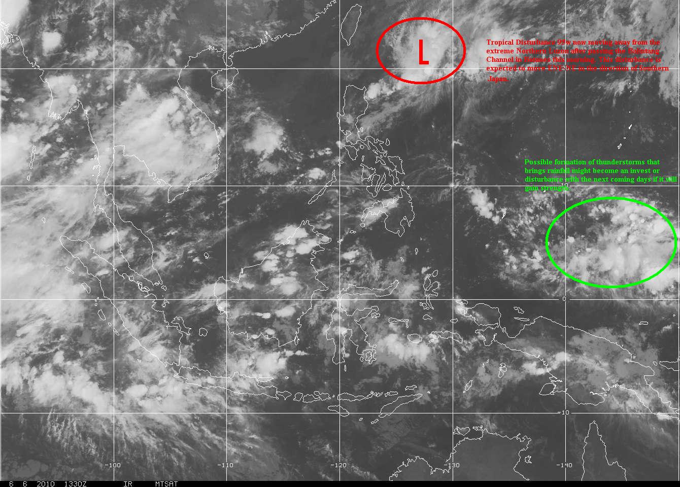
T2K Tropical Cyclone Watch [As of 12:00 PM June 07, 2010]:
Weak LPA (95W/1011 MB) moving away from Extreme Northern Luzon or near 20.2N 123.5E.
About 160 km ESE of Basco, Batanes...moving NE @ 19 kph towards Ryukyus.
Will enhance the SW Windflow across Western Luzon incl. Metro Manila.
Saturday, June 5, 2010
Tropical Disturbance 95w formed approaching Ilocos Province.... enhancing SW Windflow

T2K Tropical Cyclone Watch [As of 6:00 PM June 05, 2010]:
Developing LPA (95W/1010 MB) approaching Ilocos Provinces or near 17.7N 118.6E.
About 190 km West of Vigan City...moving ENE @ 24 kph towards Ilocos Provs.
Will enhance the SW Windflow across Western & Northern Luzon this weekend.